Archaeologists completed the elaboration of archive records of excavations at Biskupin, a fortified Iron Age settlement and one of the most important archaeological sites in Poland. The initial excavations were undertaken between 1934-39 and were interrupted by World War II, which also led to partial destruction of the original documentation.

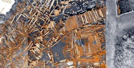
The excavations in the 1930s were undertaken by Józef Kostrzewski and Zdzisław Rajewski. The research was aided then by innovative research methods, including aerial photography, in which the pictures were taken with use of a balloon with an attached camera, and later with an observation balloon reaching the altitude of 1000 metres. The pictures obtained through these methods allowed to record the preserved structures of the Iron Age settlement, including houses, palisades, streets, ramparts, and breakwater. Until the start of World War II the researchers managed to uncover around 1 hectare – almost half of the prehistoric settlement. The war led to destruction of a large portion of the original documents, including plans of the wooden structures, cross-sections, notes, sketches, research journals, which were necessary for completion of a scientific report on the site. All that was left were a couple hundred of photographic films in museums in Warsaw, Poznań and Biskupin.
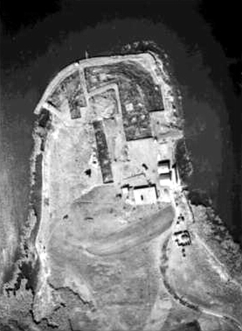
Researchers of State Archaeological Museum in Warsaw and Warsaw University of Technology managed to finish a project of scientific elaboration of preserved archive data from the pre-WW2 excavations in Biskupin. It was possible through incorporation of photogrammetry as a mean of processing archive footage, as well as creation of a GIS database including data on discovered structures. The researchers extracted archaeological features from the old photographs, evaluated them scientifically and reconstructed in the spacial hierarchy of the settlement, thus reconstructing the original layout and spacial organisation of the site. The researchers plan next to conduct a similar study on the archive data from the site acquired during post-WW2 excavations.
(by Państwowe Muzeum Archeologiczne w Warszawie, Zespół Budownictwa Ogólnego i Zrównoważonego Rozwoju z Wydziału Inżynierii Lądowej Politechniki Warszawskiej & Gazeta Pomorska)